
Histoire de l’Égypte sous le gouvernement de Mohammed-Aly, ou récit des événemens politiques et militaires qui ont eu lieu depuis le départ des Français jusqu’en 1823. Enrichi de notes par Langlès et Jomard. TWO VOLUMES + ATLAS.
Mengin, Felix.

Synopsis
First Edition. COMPLETE with the Atlas containing twelve plates of portraits, landscapes, a plan and a map, which was issued with the two volumes. Felix Mengin, son-in-law of Caffe, agent for the French Consul, was resident in Cairo for many years as a merchant. He acted as de Chateaubriand’s host in Cairo in 1806. Mengin was one of Muhammad Ali’s apologists; he wrote a sequel to his work entitled Histoire Sommaire de l’Égypte.
The importance of this historic work lies in its detailed information about Egypt’s policy towards Arabia, Syria, the European powers, and the Porte in the early 19th century. In the appendix of Volume I there is a biography of Ahmad Pasha al-Jazzar of Akka (Acre- Palestine). The preparations made by Ibrahim Pasha for the conquest of Arabia are also extensively mentioned. In Volume II, a large section entitled “Précis de l’histoire des Wahabys” is a detailed analysis of the Wahhabi doctrines, and the situation in Arabia during the early part of the 19th century. A geographical essay about Najd written by Jomard is based on observations made during the Egyptian occupation of Najd in 1820. The essay includes information about distances between major towns and villages, the limits of Najd, al-Yamamah, al-Qatif, Bahrain, al Hasa, the capital of Najd al-Dar’iyyah, and other locations. A list in French and Arabic is also published for the major towns and villages in Najd. The book is regarded as a major reference work on the Egyptian war against the inhabitants of Najd.
The plates are as follows:
1- Portrait de Mohammed-Aly, vice-roi d’Egypte, d’après un dessin de M. Le Conte de Forbin. Coloured.
2- Mourad Bey, Chef des Mamlouks. Coloured.
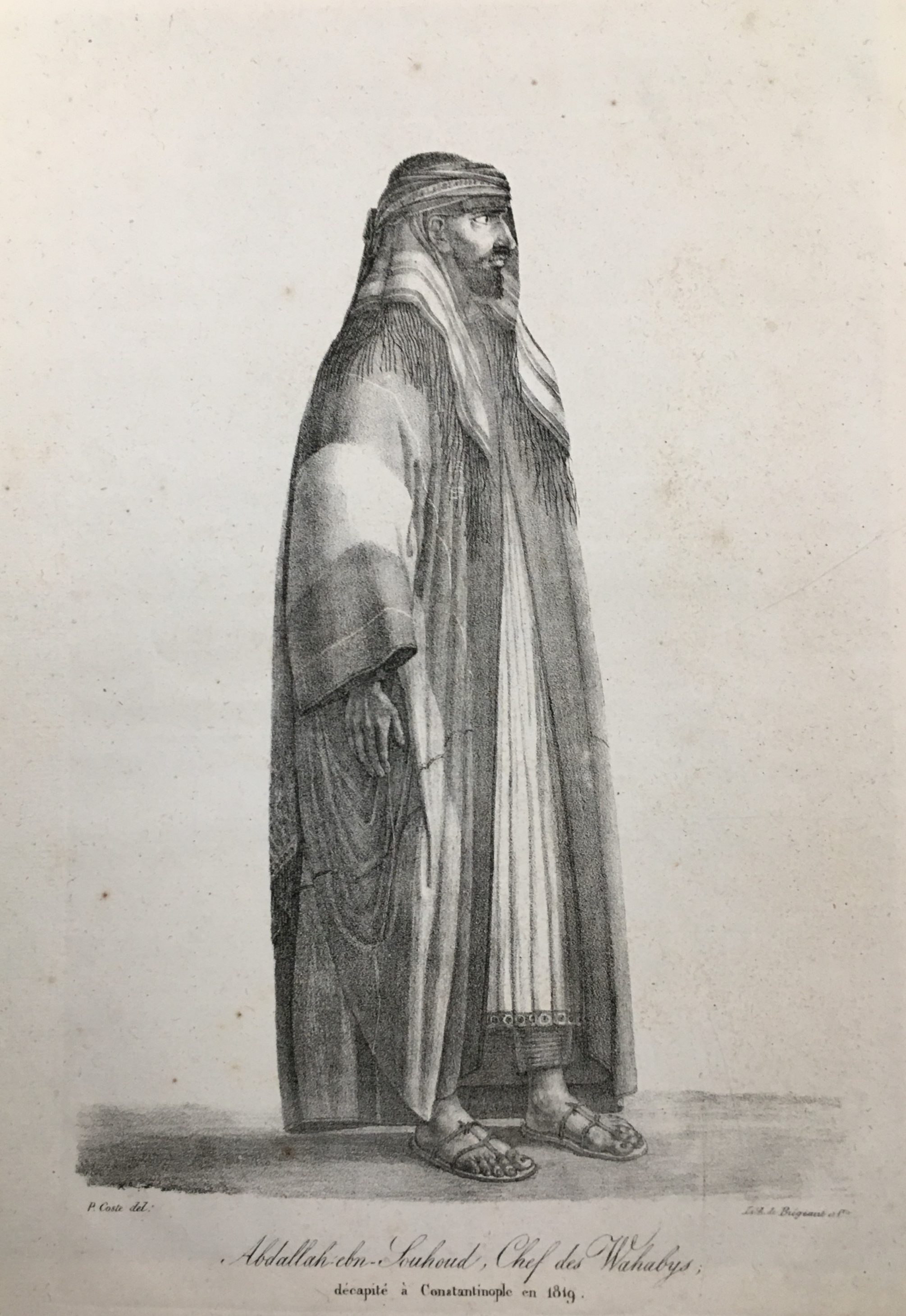
3- Abdallah Ebn Souhoud, Chef de Wahabys. Coloured.
4- Puits à roue du pays de Nedjd.
5- Vue du palais et du serail de Mohammed-Aly, à Alexandrie. 6- Le Roi de Sennar triturant du mais. Coloured.
7- Une fille de Sennar donnant audience a ses ministres.
8- Femme Arabe de la tribu des Ababdeh. Coloured.
9- Vue du palais de Mohammed-Aly, sur la place de L’Ezbekyeh, au Kaire, prise à l’époque de l’inondation.
10- Plan du nouveau canal d’Alexandrie, dit Mahmoudiyah, dressé par M. Coste, architect de Mohammed-Aly.
11- La Sainte famille se reposant sous un Sycomore à Matharyeh.
12- Carte Geographique du pays de Nedjed (gravée).
Bibliographic references: Atabey, n°802; Ibrahim-Hilmy, II, 30; Macro 1577.


