
- Books
- ARCHAEOLOGY
- ART & ARCHITECTURE
- ALGERIA
- AMERICAN ART
- ARAB ART
- ARABIC CALLIGRAPHY
- ARABIC MUSIC
- ARABIC PRINTING
- ARMENIA
- ARMENIAN ART
- ASIA
- ASIA MINOR
- ASIAN ART
- BIBLIOGRAPHY
- BOOK BINDING
- BOOKBINDING
- CALLIGRAPHY
- CARPETS
- CERAMICS
- CHRISTIANITY
- EGYPT
- EUROPE
- EUROPEAN ART
- FRANCE
- GREECE
- INDIAN ARCHITECTURE
- INDIAN ART
- IRAN
- IRAQ
- ISLAMIC ARCHITECTURE
- ISLAMIC ART
- ISLAMIC COSTUMES
- ISLAMIC JEWELLERY
- ISLAMIC SPAIN
- ISLAMIC TEXTILES
- JEWELLERY
- JORDAN
- LEBANON
- LITHOGRAPHY
- MINIATURE
- MODERN ART
- MOROCCO
- MUSIC
- NETHERLANDS
- NORTH AFRICA
- ORIENTALISM
- PALESTINE
- PERSIAN ART
- PERSIAN MINIATURE
- RUSSIA
- SYRIA
- TEXTILE
- TEXTILES
- THEATRE
- TURKEY
- TURKISH ARCHITECTURE
- TURKISH ART
- YEMEN
- BIBLIOGRAPHY
- AFRICAN ART
- AMERICANA
- ARAB GULF
- ARABIA
- ARABIAN PENINSULA
- ARABIC PRINTING
- ARABIC SCRIPT
- ARMENIA
- ASIA
- BIOGRAPHY
- CENTRAL ASIA
- CHINA
- CHRISTIANITY
- EGYPT
- GEOGRAPHY
- IRAN
- ISLAM
- ISLAMIC LITERATURE
- ISLAMIC SCIENCE
- ISLAMIC SPAIN
- JORDAN
- JUDAISM
- LEBANON
- LITERATURE
- MIDDLE EAST
- MODERN ART
- MOROCCO
- NEAR EAST
- NORTH AFRICA
- OMAN
- PALESTINE
- SAUDI ARABIA
- SAUDIA ARABIA
- SPAIN
- STAMPS
- SYRIA
- YEMEN
- BIOGRAPHY
- ALGERIA
- ARABIA
- ARABIC LITERATURE
- ASIA
- CHRISTIANITY
- EGYPT
- HISTORY
- IRAN
- IRAQ
- ISLAM
- ISLAMIC HISTORY
- ISLAMIC PHILOSOPHY
- ISLAMIC THOUGHT
- JORDAN
- KUWAIT
- LEBANON
- LEBANON & SYRIA
- LIBYA
- MIDDLE EAST
- NORTH AFRICA
- OTTOMAN HISTORY
- PALESTINE
- POETRY
- POLITICS
- SAUDI ARABIA
- SUDAN
- SYRIA
- SYRIA & LEBANON
- T. E. LAWRENCE
- TRAVEL
- TURKEY
- YEMEN
- CARTOGRAPHY
- ECONOMY
- GEOGRAPHY
- AFRICA
- ALGERIA
- ARAB GULF
- ARABIA
- ARABIAN PENINSULA
- ASIA
- ASTRONOMY
- BRITAIN
- CARTOGRAPHY
- EGYPT
- EUROPE
- GEMEALOGY
- HISTORY
- IRAN
- IRAQ
- ISLAM
- ISLAMIC ART
- ISLAMIC PILGRIMAGE
- ISLAMIC SCIENCE
- ISLAMIC SPAIN
- JORDAN
- KUWAIT
- LEBANON
- MIDDLE EAST
- NORTH AFRICA
- OIL INDUSTRY
- OMAN
- ORIENTALISM
- PALESTINE
- PERSIAN EMPIRE
- PETROL
- RED SEA
- SAUDI ARABIA
- SUDAN
- SYRIA
- SYRIA & LEBANON
- TRAVEL
- TUNIS
- TURKEY
- YEMEN
- HISTORY
- AFRICAN HISTORY
- ALGERIA
- ARAB
- ARAB GULF
- ARAB HISTORY
- ARABIA
- ARABIAN PENINSULA
- ARABIC PRINTING
- ARABS
- ARMENIA
- ASIA
- ASIA MINOR
- ASIAN HISTORY
- AVIATION
- BAHRAIN
- BALKAN WAR
- BIOGRAPHY
- CENTRAL AMERICA
- CENTRAL ASIA
- CHRISTIANITY
- CRUSADE WARS
- CRUSADES
- CRUSADES HISTORY
- CRUSADES WARS
- EASTERN CHURCH
- EASTERN QUESTION
- EASTERN QUESTIONS
- EGYPT
- EGYPTIAN HISTORY
- EUROPE
- EUROPEAN HISTORY
- FRANCE
- FRENCH HISTORY
- GERMANY
- GREECE
- INDIA
- IRAN
- IRAN-IRAQ
- IRAQ
- IRAQI REVOLUTION
- iSLAM
- ISLAMIC ARCHITECTURE
- ISLAMIC HISTORY
- ISLAMIC PILGRIMAGE
- ISLAMIC SCIENCE
- ISLAMIC SPAIN
- ITALY
- JORDAN
- JUDAICA
- KURDISH HISTORY
- KURDS
- KUWAIT
- LAW
- LEBANON
- LYBIA
- MIDDLE EAST
- MILITARY
- MONGOL EMPIRE
- MOROCCO
- NEAR EAST
- NIGERIA
- NORTH AFRICA
- NORTH HISTORY
- OMAN
- OTTOMAN EMPIRE
- OTTOMAN HISTORY
- OTTOMAN PERIOD
- OTTOMAN- RUSSIAN WAR
- PALESTINE
- PERSIA
- PERSIAN HISTORY
- PERSIAN LITERATURE
- RED SEA
- RELIGION
- RUSSIA
- SAUDI ARABIA
- SCIENCE
- SOCIAL STUDIES
- SUDAN
- SYRIA
- SYRIA & LEBANON
- SYRIAN HISTORY
- TRAVEL
- TURKEY
- YEMEN
- LINGUISTICS
- LITERATURE
- AFRICAN LITERATURE
- ARABIC LITERATURE
- ARABIC POETRY
- ASIA
- ASIAN LITERATURE
- BERBER LITERATURE
- CHINA
- EGYPT
- ENGLAND
- ENGLISH
- EROTISM
- EUROPE
- EUROPEAN
- EUROPEAN LITERATURE
- FOLK TALES
- FRENCH
- GERMAN
- GERMAN LITERATURE
- GERMANY
- GREECE
- GREEK LITERATURE
- HISTORY
- INDIA
- INDIAN PHILOSOPHY
- ISLAM
- ISLAMIC PHILOSOPHY
- ISLAMIC SPAIN
- JUDAIC
- LINGUISTICS
- MIDDLE EAST
- MUSIC
- ORIENTALISM
- PERSIAN
- PERSIAN LITERATURE
- POETRY
- SPANISH
- SUFISM
- SWEDEN
- TURKEY
- MANUSCRIPTS
- MAPS
- NATURAL HISTORY
- NOT FOUND
- OUT OF STOCK
- PAINTING
- PERIODICAL
- PHOTOGRAPHY
- PLATES
- POLITICS
- ALGERIA
- ARAB GULF
- ARABIA
- ARABIAN GULF
- ARABIAN PENINSULA
- ARGENTINA
- ARMENIA
- ASIA
- BAHRAIN
- BALKAN
- Canada
- CENTRAL ASIA
- ECONOMY
- EGYPT
- ENGLAND
- EUROPE
- GERMANY
- HISTORY
- INDIAN OCEAN
- IRAN
- IRAQ
- ISLAMIC HISTORY
- JORDAN
- KUWAIT
- LATIN AMERICA
- LEBANON
- LIBYA
- MALAYSIA
- MIDDLE EAST
- NEAR EAST
- NORTH AFRICA
- OMAN
- PALESTINE
- PERSIAN GULF
- RELIGION
- RUSSIA
- SAUDI ARABIA
- SOUTHERN ASIA
- SUDAN
- SYRIA
- SYRIA & LEBANON
- TRAVELS
- TUNISIA
- TURKEY
- UNITED ARAB EMIRATES
- YEMEN
- POSTER
- RELIGION
- ASIA
- BIOGRAPHY
- CHRISTIANITY
- CHURCH HISTORY
- CRUSADE WARS
- CRUSADES
- DRUSE
- DRUZE
- EASTERN CHURCH
- EGYPT
- HINDUISM
- HISTORY
- INDIA
- IRAN
- ISLAM
- ISLAMIC HISTORY
- ISLAMIC LAW
- ISLAMIC PHILOSOPHY
- ISLAMIC PILGRIMAGE
- ISLAMIC SOCIETY
- ISLAMIC SPAIN
- ISLAMIC TAX LAW
- ISLAMIC TEXTS
- ISLAMIC THEOLOGY
- JUDAICA
- JUDAISM
- LEBANON
- MIDDLE EAST
- OMAN
- PHILOSOPHY
- PROPHET MUHAMMAD
- RARE ISLAM
- SAUDI ARABIA
- SCIENCE
- SCIENCES
- SOCIAL STUDIES
- AFRICA
- ARAB GULF
- ARAB WOMEN
- ARABIA
- BAHRAIN
- BEDOUINS
- CHINA
- COOKERY
- CULINARY
- EGYPT
- EGYPT MEDICINE
- EUROPE
- FREEMASONARY
- INDIA
- ISLAM
- ISLAMIC LAW
- ISLAMIC SOCIETY
- ISLAMIC SPAIN
- JORDAN
- JUDAICA
- LAW
- LEBANON
- MIDDLE EAST
- NEAR EAST
- NORTH AFRICA
- OMAN
- ORIENTALISM
- PALESTINE
- PERSIAN GULF
- SAUDI ARABIA
- SPORTS
- SUDAN
- SYRIA
- TURKEY
- UNITED ARAB EMIRATES
- T. E. LAWRENCE
- TRAVEL
- AFRICA
- ARABIA
- ARABIAN PENINSULA
- ARMENIA
- ASIA
- CENTRAL AMERICA
- CENTRAL ASIA
- CHINA
- EGYPT
- EGYPTE
- EUROPE
- GREECE
- HISTORY
- HOLY LAND
- HOLYLAND
- IRAN
- IRAQ
- ISLAM
- ISLAMIC EMPIRE
- ISLAMIC PILGRIMAGE
- ISLAMIC SPAIN
- JORDAN
- LEBANON
- LEVANT
- MEXICO
- MIDDLE EAST
- NATURAL HISTORY
- NEAR EAST
- NORTH AFRICA
- NORTH POLE
- OIL INDUSTRY
- OMAN
- OTTOMAN EMPIRE
- PALESTINE
- PERSIA
- PERSIAN ART
- PILGRIMAGE
- RED SEA
- RUSSIA
- SAUDI ARABIA
- SUDAN
- SWITZERLAND
- SYRIA
- SYRIA & LEBANON
- TURKEY
- YEMEN
- TRAVEL & HISTORY
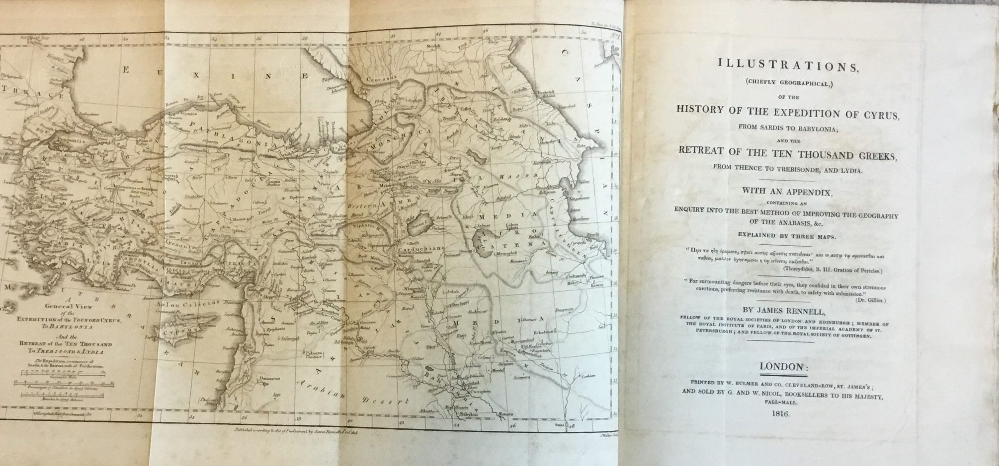
Illustrations (Chiefly Geographical) of the History of the Expedition of Cyrus from Sardis to Babylonia and the retreat of the ten thousand Greeks, from Thence to Trebisonde and Lydia.
Rennell, James 1742-1830.
Synopsis
Major James Rennell, was an English geographer, historian and a pioneer of oceanography. He produced some of the first accurate maps of Bengal at one inch to five miles as well as accurate outlines of India and served as Surveyor General of Bengal. Rennell has been called the Father of Indian Geography and as the Father of Oceanography. In 1830 he was one of the founders of the Royal Geographical Society in London.
He also contributed papers to Archaeologia on the site of Babylon, the island of St Paul’s shipwreck, and the landing-place of Caesar in Britain. Rennell published a book titled Memoir of a map of Hindoostan (1788).
His plan for a comprehensive study of western Asia resulted in a two-volume study of the geography of Herodotus and A Treatise on the Comparative Geography of Western Asia (1831), among other works.


