
- Books
- ARCHAEOLOGY
- ART & ARCHITECTURE
- ALGERIA
- AMERICAN ART
- ARAB ART
- ARABIC CALLIGRAPHY
- ARABIC MUSIC
- ARABIC PRINTING
- ARMENIA
- ARMENIAN ART
- ASIA
- ASIAN ART
- BIBLIOGRAPHY
- BOOK BINDING
- BOOKBINDING
- CALLIGRAPHY
- CARPETS
- CERAMICS
- EGYPT
- EUROPE
- EUROPEAN ART
- FRANCE
- GREECE
- HOLY LAND
- INDIAN ARCHITECTURE
- INDIAN ART
- IRAN
- IRAQ
- ISLAMIC ARCHITECTURE
- ISLAMIC ART
- ISLAMIC COSTUMES
- ISLAMIC JEWELLERY
- ISLAMIC SPAIN
- ISLAMIC TEXTILES
- JEWELLERY
- JORDAN
- LEBANON
- LITHOGRAPHY
- MINIATURE
- MODERN ART
- MOROCCO
- MUSIC
- NETHERLANDS
- NORTH AFRICA
- ORIENTALISM
- PALESTINE
- PERSIAN ART
- PERSIAN MINIATURE
- RUSSIA
- SYRIA
- TEXTILE
- TEXTILES
- THEATRE
- TURKEY
- TURKISH ARCHITECTURE
- TURKISH ART
- YEMEN
- BIBLIOGRAPHY
- AFRICAN ART
- AMERICANA
- ARAB GULF
- ARABIA
- ARABIAN PENINSULA
- ARABIC PRINTING
- ARMENIA
- ASIA
- BIOGRAPHY
- CENTRAL ASIA
- CHINA
- CHRISTIANITY
- EGYPT
- GEOGRAPHY
- IRAN
- ISLAM
- ISLAMIC LITERATURE
- ISLAMIC SCIENCE
- ISLAMIC SPAIN
- JORDAN
- JUDAISM
- LEBANON
- LITERATURE
- MIDDLE EAST
- MODERN ART
- MOROCCO
- NEAR EAST
- NORTH AFRICA
- OMAN
- PALESTINE
- SAUDI ARABIA
- SAUDIA ARABIA
- SPAIN
- STAMPS
- SYRIA
- YEMEN
- BIOGRAPHY
- ALGERIA
- ARABIA
- ARABIC LITERATURE
- ASIA
- CHRISTIANITY
- EGYPT
- HISTORY
- IRAN
- IRAQ
- ISLAM
- ISLAMIC HISTORY
- ISLAMIC PHILOSOPHY
- ISLAMIC THOUGHT
- JORDAN
- KUWAIT
- LEBANON
- LEBANON & SYRIA
- LIBYA
- MIDDLE EAST
- NORTH AFRICA
- OTTOMAN HISTORY
- PALESTINE
- POETRY
- POLITICS
- SAUDI ARABIA
- SUDAN
- SYRIA
- SYRIA & LEBANON
- T E LAWRENCE
- T. E. LAWRENCE
- TRAVEL
- TURKEY
- YEMEN
- ECONOMY
- GEOGRAPHY
- AFRICA
- ALGERIA
- ARAB GULF
- ARABIA
- ARABIAN PENINSULA
- ASIA
- ASTRONOMY
- CARTOGRAPHY
- EGYPT
- EUROPE
- GEMEALOGY
- HISTORY
- IRAN
- IRAQ
- ISLAM
- ISLAMIC ART
- ISLAMIC PILGRIMAGE
- ISLAMIC SCIENCE
- ISLAMIC SPAIN
- JORDAN
- KUWAIT
- LEBANON
- MIDDLE EAST
- NORTH AFRICA
- OIL INDUSTRY
- ORIENTALISM
- PALESTINE
- PERSIAN EMPIRE
- PETROL
- RED SEA
- SAUDI ARABIA
- SUDAN
- SYRIA
- SYRIA & LEBANON
- TRAVEL
- TUNIS
- TURKEY
- YEMEN
- HISTORY
- AFRICAN HISTORY
- ALGERIA
- ARAB
- ARAB GULF
- ARAB HISTORY
- ARABIA
- ARABIAN PENINSULA
- ARABIC PRINTING
- ARABS
- ARMENIA
- ASIA
- ASIA MINOR
- ASIAN HISTORY
- AVIATION
- BAHRAIN
- BALKAN WAR
- BIOGRAPHY
- CENTRAL AMERICA
- CENTRAL ASIA
- CHRISTIANITY
- CRUSADE WARS
- CRUSADES
- CRUSADES HISTORY
- CRUSADES WARS
- EASTERN CHURCH
- EASTERN QUESTIONS
- EGYPT
- EGYPTIAN HISTORY
- EUROPE
- EUROPEAN HISTORY
- FRANCE
- FRENCH HISTORY
- GERMANY
- GREECE
- INDIA
- IRAN
- IRAN-IRAQ
- IRAQ
- IRAQ ARAB GULF
- iSLAM
- ISLAMIC HISTORY
- ISLAMIC PILGRIMAGE
- ISLAMIC SCIENCE
- ISLAMIC SPAIN
- ITALY
- JORDAN
- JUDAICA
- KURDS
- KUWAIT
- LAW
- LEBANON
- LYBIA
- MIDDLE EAST
- MILITARY
- MONGOL EMPIRE
- MOROCCO
- NEAR EAST
- NIGERIA
- NORTH AFRICA
- NORTH HISTORY
- OMAN
- OTTOMAN EMPIRE
- OTTOMAN HISTORY
- OTTOMAN PERIOD
- OTTOMAN- RUSSIAN WAR
- PALESTINE
- PERSIA
- PERSIAN HISTORY
- PERSIAN LITERATURE
- RED SEA
- RELIGION
- RUSSIA
- SAUDI ARABIA
- SCIENCE
- SUDAN
- SYRIA
- SYRIA & LEBANON
- SYRIAN HISTORY
- TRAVEL
- TURKEY
- YEMEN
- LINGUISTICS
- LITERATURE
- AFRICAN LITERATURE
- ARABIC LITERATURE
- ARABIC POETRY
- ART & ARCHITECTURE
- ASIA
- ASIAN LITERATURE
- BERBER LITERATURE
- CHINA
- EGYPT
- ENGLAND
- ENGLISH
- EROTISM
- EUROPE
- EUROPEAN
- EUROPEAN LITERATURE
- FOLK TALES
- FRENCH
- GERMAN
- GERMAN LITERATURE
- GERMANY
- GREECE
- GREEK LITERATURE
- HISTORY
- INDIA
- INDIAN PHILOSOPHY
- ISLAM
- ISLAMIC PHILOSOPHY
- ISLAMIC SPAIN
- LINGUISTICS
- MIDDLE EAST
- MUSIC
- ORIENTALISM
- PALESTINE
- PERSIAN
- PERSIAN LITERATURE
- POETRY
- SPANISH
- SWEDEN
- TURKEY
- MANUSCRIPTS
- MAPS
- NATURAL HISTORY
- OUT OF STOCK
- PAINTING
- PERIODICAL
- PHOTOGRAPHY
- POLITICS
- ALGERIA
- ARAB GULF
- ARABIA
- ARABIAN GULF
- ARABIAN PENINSULA
- ARGENTINA
- ASIA
- BAHRAIN
- BALKAN
- Canada
- ECONOMY
- EGYPT
- ENGLAND
- EUROPE
- GERMANY
- GULF
- HISTORY
- INDIAN OCEAN
- IRAN
- IRAQ
- ISLAMIC HISTORY
- JORDAN
- KUWAIT
- LATIN AMERICA
- LEBANON
- LIBYA
- MALAYSIA
- MIDDLE EAST
- NEAR EAST
- NORTH AFRICA
- OMAN
- PALESTINE
- PERSIAN GULF
- RELIGION
- RUSSIA
- SAUDI ARABIA
- SOUTHERN ASIA
- SUDAN
- SYRIA
- SYRIA & LEBANON
- TUNISIA
- TURKEY
- UNITED ARAB EMIRATES
- YEMEN
- POSTER
- RELIGION
- ASIA
- BIOGRAPHY
- CHRISTIANITY
- CHURCH HISTORY
- CRUSADE WARS
- CRUSADES
- DRUSE
- DRUZE
- EGYPT
- HINDUISM
- HISTORY
- INDIA
- IRAN
- ISLAM
- ISLAMIC HISTORY
- ISLAMIC LAW
- ISLAMIC PHILOSOPHY
- ISLAMIC PILGRIMAGE
- ISLAMIC SOCIETY
- ISLAMIC SPAIN
- ISLAMIC TAX LAW
- ISLAMIC TEXTS
- ISLAMIC THEOLOGY
- JUDAICA
- JUDAISM
- LEBANON
- MIDDLE EAST
- PHILOSOPHY
- PROPHET MUHAMMAD
- RARE ISLAM
- SAUDI ARABIA
- SCIENCE
- SCIENCES
- SOCIAL STUDIES
- AFRICA
- ARAB GULF
- ARAB WOMEN
- ARABIA
- BAHRAIN
- BEDOUINS
- COOKERY
- CULINARY
- EGYPT
- EGYPT MEDICINE
- EUROPE
- FREEMASONARY
- INDIA
- ISLAM
- ISLAMIC LAW
- ISLAMIC SOCIETY
- JORDAN
- JUDAICA
- LAW
- LEBANON
- MIDDLE EAST
- NEAR EAST
- NORTH AFRICA
- ORIENTALISM
- PALESTINE
- PERSIAN GULF
- SAUDI ARABIA
- SPORTS
- SUDAN
- SYRIA
- TURKEY
- UNITED ARAB EMIRATES
- T. E. LAWRENCE
- TRAVEL
- AFRICA
- ARABIA
- ARABIAN PENINSULA
- ARMENIA
- ASIA
- CENTRAL AMERICA
- CENTRAL ASIA
- CHINA
- EGYPT
- EGYPTE
- EUROPE
- GREECE
- HISTORY
- HOLY LAND
- HOLYLAND
- IRAN
- IRAQ
- ISLAM
- ISLAMIC EMPIRE
- ISLAMIC PILGRIMAGE
- ISLAMIC SPAIN
- JORDAN
- LEBANON
- LEVANT
- MIDDLE EAST
- NATURAL HISTORY
- NEAR EAST
- NORTH AFRICA
- NORTH POLE
- OIL INDUSTRY
- OMAN
- OTTOMAN EMPIRE
- PALESTINE
- PERSIA
- PERSIAN ART
- PILGRIMAGE
- RED SEA
- RUSSIA
- SAUDI ARABIA
- SOUTH AMERICA
- SUDAN
- SWITZERLAND
- SYRIA
- SYRIA & LEBANON
- TURKEY
- YEMEN
- TRAVEL & HISTORY
Two Plans: A. Environs de Beyrout. B. Region d’Alexandrette.
Anon. Cartography.
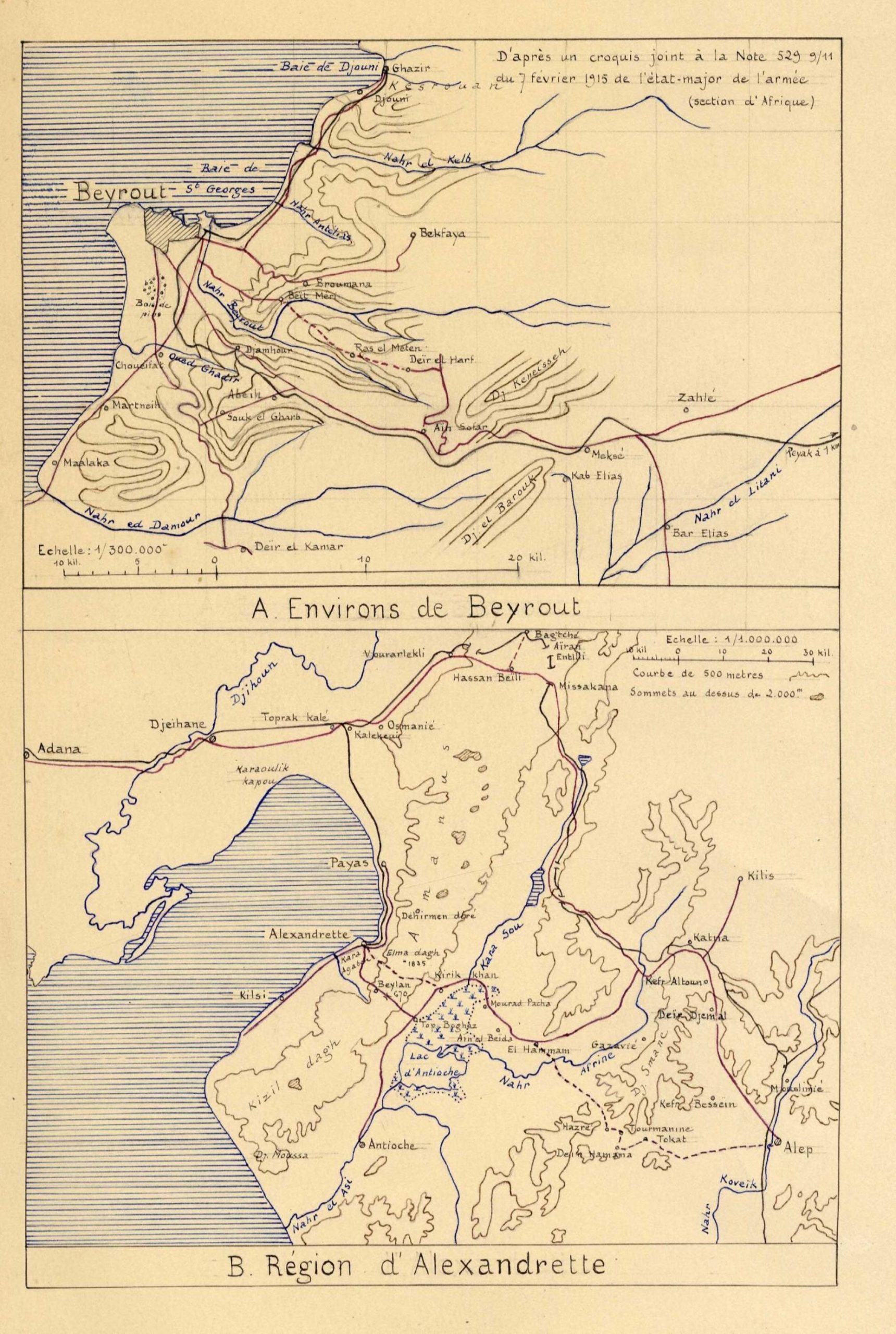
Ink drawn on a single sheet, first map 18 x 12 cm, d’apres un croquis a la note 529 9/11 du Fevrier 1915 de l’etat-major de l’armee (section d’Afrique) showing North the Bay of Jounieh, South the Damour River and East the Litani River. Second map 18 x 12 cm showing the whole Bay of Alexandretta from Nahr al-Asi South up to Hassan Beili North and Aleppo to the South-East. Echelle 1/1000.000


