
Geographiae Cl. Ptolemaei Pars secunda, continens praeter antiqvas ipsivs Ptol. recentiores etiam tabulas, quæ Vniuersæ terræ faciem nostro æuo cognitam exhibent. THREE VOLUMES IN ONE.
Ptolemy, active 2nd century / Giovanni Antonio Magino Patavino (Edt).

Synopsis
Giovanni Antonio Magini was an Italian astronomer, astrologer, cartographer, and mathematician (1555 – 1617). Dedicating himself to astronomy, in 1582 he wrote Ephemerides coelestium motuum, translated into Italian the following year. In 1588 he was chosen over Galileo Galilei for the Chair of Mathematics at the University of Bologna after the death of Egnatio Danti. In his De Planis Triangulis (1592), he described the use of quadrants in surveying and astronomy. In 1592 Magini published Tabula tetragonica, and in 1606 devised extremely accurate trigonometric tables. He also worked on the geometry of the sphere and applications of trigonometry, for which he invented calculating devices. He also worked on the problem of mirrors and published on the theory of concave spherical mirrors. He also published a commentary on Ptolemy’s Geographia.
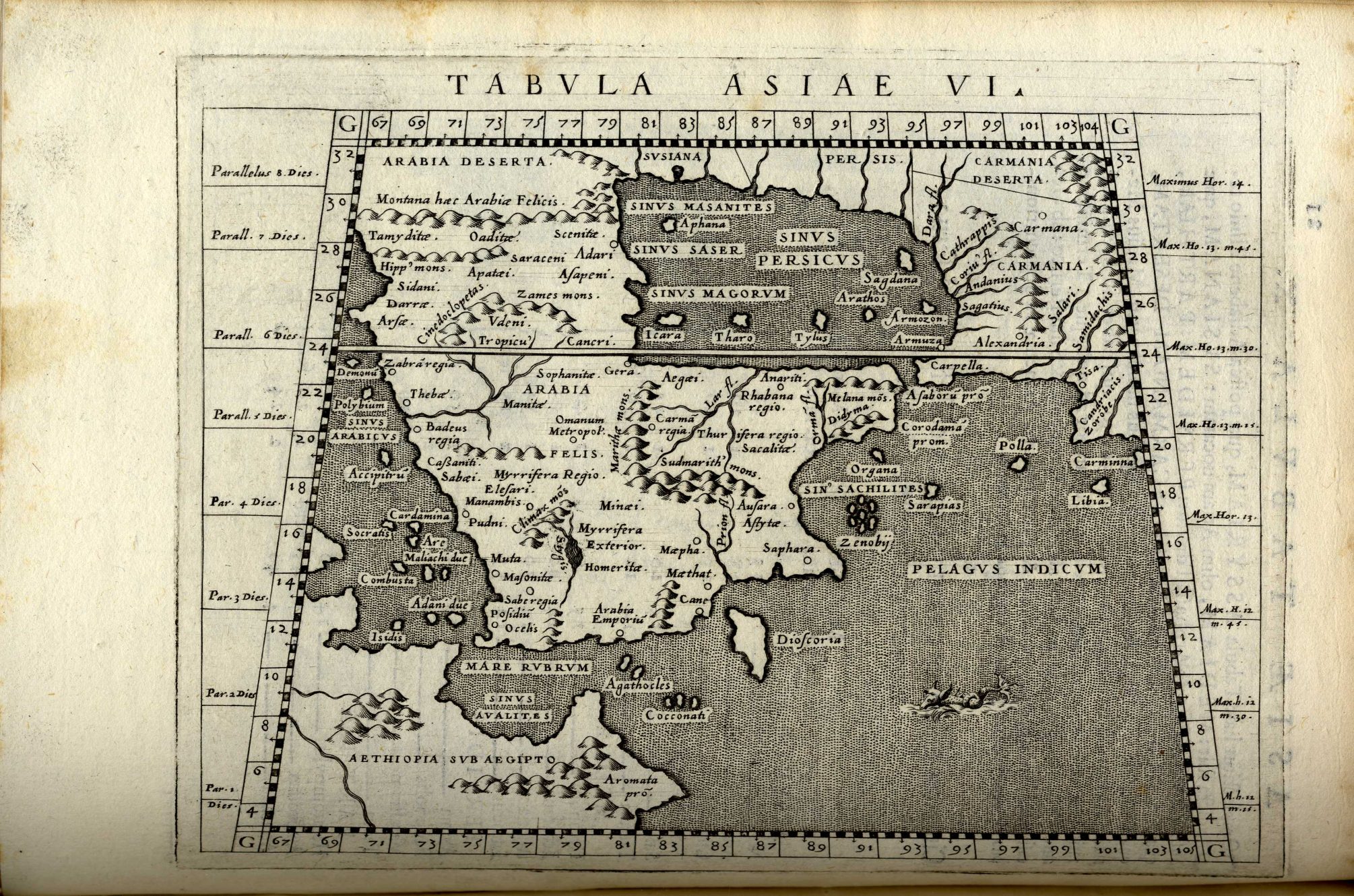
Magini is well known for his reduced size edition of Ptolemy’s Geographiae published in Italian as “Geografia cioe Descrittione Universale della Terra”
1596 Venice. Latin text. Printer Heredes Simoni Galignani. 64 copper-plate maps.
1597 Cologne. Latin text. Printer Petrus Keschedt. 64 copper-plate maps.
1598 Venice. Italian text. Printer Gio. Battista & Giorgio Galignani Fratelli. Artist Girolamo Porro. 64 copper-plate maps.
1608 Cologne. Latin text. Printer Antonius Becker. 63 copper-plate maps.
1617 Arnheim. Latin text. Printer Ioannes Ianssonius. 64 copper-plate maps.
1621 Padua. Italian text. Printer Paolo and Francesco Galignani. 64 copper-plate maps.
As a cartographer, his life’s work was the preparation of Italia or the Atlante geografico d’Italia (Geographic Atlas of Italy), printed posthumously by Magini’s son in 1620. This was intended to include maps of every Italian region with exact nomenclature and historical notes. A major project, its production, which began in 1594, proved expensive and Magini assumed various additional posts in order to fund it, including becoming tutor in mathematics to the sons of Vincenzo I of Gonzaga, Duke of Mantua, a major patron of the arts and sciences. He also served as court astrologer. The Duke of Mantua, to whom the Atlas is dedicated, assisted him on this project and allowed for maps of the various states of Italy to be brought to Magini. The governments of Messina and Genoa also assisted Magini financially in this project. Magini did not do any of the mapping himself.
He was also interested in pursuits which today would be considered pseudoscientific. A strong supporter of astrology, he defended its use in medicine in his De astrologica ratione (Venice, 1607). Magini collaborated closely with Valentine Naibod, and in this book he published De annui temporis mensura in Directionibus and De Directionibus from Naibod’s unfinished manuscript Claudii Ptolemaei Quadripartitae Constructionis Apotelesmata Commentarius novus et Eiusdem Conversio nova. He was also interested in metoposcopy. He corresponded with Tycho Brahe, Clavius, Abraham Ortelius, and Johann Kepler. Antonio Favaro edited his correspondence in 1886. The lunar crater Maginus is named after Magini.


