
Three Nautical Charts: Zanzibar, East Coast of Aden and Red Sea Eritrean Coast, Massawa,
British Admiralty Nautical Charts.


Synopsis
N (= No. 27): Africa – East Coast. Zanzibar Island. Approaches to Zanzibar. Ras Nungwi to Yambwa Ngome Reefs. Dimensions: 103.3 x 70.6 cm. From a Survey by Captain E. G. Irving, H.M.S. ‘Dalrymple’, 1951. Yambwa Ngome Reefs to Ras Mkita and Outer Approaches from Surveys by Commodore R. Bill and Commodore J. T. K. Paisley, H.M.S. ‘Dalrymple’, 1953-55.- Small corrections: 1957, 1958, 1959, 1963, 1965, 1966, 1967, 1968, 1982, 1984.- London: Published at the Admiralty, 7th September 1956, under the Superintendence of Commodore K. St. B. Collins, Hydrographer. [No. 665].
O (= No. 28): Africa – East Coast. Massawa Harbour including Khor Dakliyat and Massawa South Anchorage. Dimensions: 104 x 71.3 cm. From the Italian Government Charts to 1937. With additions and corrections by Lieutenant Commodore R. H. Kennedy, H.M.S. ‘Arpha’ 1942. With corrections to 1954.- Large corrections: 25th February 1955; Small corrections: 1956, 1957, 1959, 1960, 1961, 1964, 1965, 1967, 1969, 1972, 1984.- London: Published at the Admiralty, 7th July 1939, under the Superintendence of Vice-Admiral J.A. Edgell, Hydrographer. New Editions: 6th August 1943. Engraved 1939; Positive 1977 [No. 460].
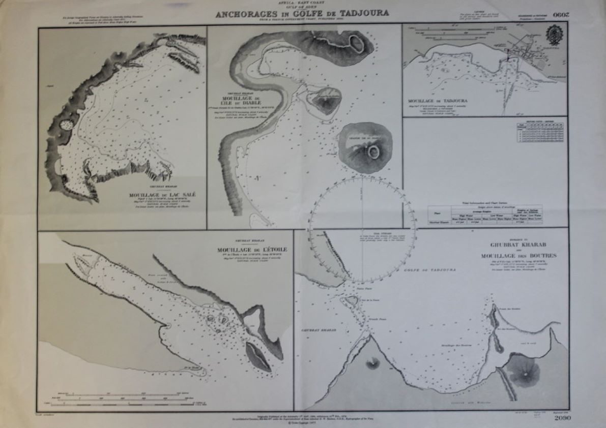
P (= No. 38): Africa – East Coast. Gulf of Aden. Anchorages in Golfe de Tadjoura. Dimensions: 70.9 x 51.9 cm. From a French Government Chart, published 1893. [With Five Insets, as follows]: Ghubbat Kharab. Mouillage du Lac Sale; Ghubbat Kharab. Mouillage de L’Ile du Diable; Mouillage de Tadjoura; Ghubbat Kharab. Mouillage de L’Etoile; [and] Entrance to Ghubbat Kharab and Mouillage des Boutres..- [London]: Originally Published at the Admiralty, 1st October 1894, withdrawn 15th February 1974; Re-published, Taunton, 18th March 1977, under the Superintendence of Rear-Admiral D. W. Haslam, Hydrographer. Engraved 1894. [No. 2090].


