
- Books
- ARCHAEOLOGY
- ART & ARCHITECTURE
- ALGERIA
- AMERICAN ART
- ARAB ART
- ARABIC CALLIGRAPHY
- ARABIC MUSIC
- ARABIC PRINTING
- ARMENIA
- ARMENIAN ART
- ASIA
- ASIAN ART
- BIBLIOGRAPHY
- BOOK BINDING
- BOOKBINDING
- CALLIGRAPHY
- CARPETS
- CERAMICS
- EGYPT
- EUROPE
- EUROPEAN ART
- FRANCE
- GREECE
- HOLY LAND
- INDIAN ARCHITECTURE
- INDIAN ART
- IRAN
- IRAQ
- ISLAMIC ARCHITECTURE
- ISLAMIC ART
- ISLAMIC COSTUMES
- ISLAMIC JEWELLERY
- ISLAMIC SPAIN
- ISLAMIC TEXTILES
- JEWELLERY
- JORDAN
- LEBANON
- LITHOGRAPHY
- MINIATURE
- MODERN ART
- MOROCCO
- MUSIC
- NETHERLANDS
- NORTH AFRICA
- ORIENTALISM
- PALESTINE
- PERSIAN ART
- PERSIAN MINIATURE
- RUSSIA
- SYRIA
- TEXTILE
- TEXTILES
- THEATRE
- TURKEY
- TURKISH ARCHITECTURE
- TURKISH ART
- YEMEN
- BIBLIOGRAPHY
- AFRICAN ART
- AMERICANA
- ARAB GULF
- ARABIA
- ARABIAN PENINSULA
- ARABIC PRINTING
- ARMENIA
- ASIA
- BIOGRAPHY
- CENTRAL ASIA
- CHINA
- CHRISTIANITY
- EGYPT
- GEOGRAPHY
- IRAN
- ISLAM
- ISLAMIC LITERATURE
- ISLAMIC SCIENCE
- ISLAMIC SPAIN
- JORDAN
- JUDAISM
- LEBANON
- LITERATURE
- MIDDLE EAST
- MODERN ART
- MOROCCO
- NEAR EAST
- NORTH AFRICA
- OMAN
- PALESTINE
- SAUDI ARABIA
- SAUDIA ARABIA
- SPAIN
- STAMPS
- SYRIA
- YEMEN
- BIOGRAPHY
- ALGERIA
- ARABIA
- ARABIC LITERATURE
- ASIA
- CHRISTIANITY
- EGYPT
- HISTORY
- IRAN
- IRAQ
- ISLAM
- ISLAMIC HISTORY
- ISLAMIC PHILOSOPHY
- ISLAMIC THOUGHT
- JORDAN
- KUWAIT
- LEBANON
- LEBANON & SYRIA
- LIBYA
- MIDDLE EAST
- NORTH AFRICA
- OTTOMAN HISTORY
- PALESTINE
- POETRY
- POLITICS
- SAUDI ARABIA
- SUDAN
- SYRIA
- SYRIA & LEBANON
- T E LAWRENCE
- T. E. LAWRENCE
- TRAVEL
- TURKEY
- YEMEN
- ECONOMY
- GEOGRAPHY
- AFRICA
- ALGERIA
- ARAB GULF
- ARABIA
- ARABIAN PENINSULA
- ASIA
- ASTRONOMY
- CARTOGRAPHY
- EGYPT
- EUROPE
- GEMEALOGY
- HISTORY
- IRAN
- IRAQ
- ISLAM
- ISLAMIC ART
- ISLAMIC PILGRIMAGE
- ISLAMIC SCIENCE
- ISLAMIC SPAIN
- JORDAN
- KUWAIT
- LEBANON
- MIDDLE EAST
- NORTH AFRICA
- OIL INDUSTRY
- ORIENTALISM
- PALESTINE
- PERSIAN EMPIRE
- PETROL
- RED SEA
- SAUDI ARABIA
- SUDAN
- SYRIA
- SYRIA & LEBANON
- TRAVEL
- TUNIS
- TURKEY
- YEMEN
- HISTORY
- AFRICAN HISTORY
- ALGERIA
- ARAB
- ARAB GULF
- ARAB HISTORY
- ARABIA
- ARABIAN PENINSULA
- ARABIC PRINTING
- ARABS
- ARMENIA
- ASIA
- ASIA MINOR
- ASIAN HISTORY
- AVIATION
- BAHRAIN
- BALKAN WAR
- BIOGRAPHY
- CENTRAL AMERICA
- CENTRAL ASIA
- CHRISTIANITY
- CRUSADE WARS
- CRUSADES
- CRUSADES HISTORY
- CRUSADES WARS
- EASTERN CHURCH
- EASTERN QUESTIONS
- EGYPT
- EGYPTIAN HISTORY
- EUROPE
- EUROPEAN HISTORY
- FRANCE
- FRENCH HISTORY
- GERMANY
- GREECE
- INDIA
- IRAN
- IRAN-IRAQ
- IRAQ
- IRAQ ARAB GULF
- iSLAM
- ISLAMIC HISTORY
- ISLAMIC PILGRIMAGE
- ISLAMIC SCIENCE
- ISLAMIC SPAIN
- ITALY
- JORDAN
- JUDAICA
- KURDS
- KUWAIT
- LAW
- LEBANON
- LYBIA
- MIDDLE EAST
- MILITARY
- MONGOL EMPIRE
- MOROCCO
- NEAR EAST
- NIGERIA
- NORTH AFRICA
- NORTH HISTORY
- OMAN
- OTTOMAN EMPIRE
- OTTOMAN HISTORY
- OTTOMAN PERIOD
- OTTOMAN- RUSSIAN WAR
- PALESTINE
- PERSIA
- PERSIAN HISTORY
- PERSIAN LITERATURE
- RED SEA
- RELIGION
- RUSSIA
- SAUDI ARABIA
- SCIENCE
- SUDAN
- SYRIA
- SYRIA & LEBANON
- SYRIAN HISTORY
- TRAVEL
- TURKEY
- YEMEN
- LINGUISTICS
- LITERATURE
- AFRICAN LITERATURE
- ARABIC LITERATURE
- ARABIC POETRY
- ART & ARCHITECTURE
- ASIA
- ASIAN LITERATURE
- BERBER LITERATURE
- CHINA
- EGYPT
- ENGLAND
- ENGLISH
- EROTISM
- EUROPE
- EUROPEAN
- EUROPEAN LITERATURE
- FOLK TALES
- FRENCH
- GERMAN
- GERMAN LITERATURE
- GERMANY
- GREECE
- GREEK LITERATURE
- HISTORY
- INDIA
- INDIAN PHILOSOPHY
- ISLAM
- ISLAMIC PHILOSOPHY
- ISLAMIC SPAIN
- LINGUISTICS
- MIDDLE EAST
- MUSIC
- ORIENTALISM
- PALESTINE
- PERSIAN
- PERSIAN LITERATURE
- POETRY
- SPANISH
- SWEDEN
- TURKEY
- MANUSCRIPTS
- MAPS
- NATURAL HISTORY
- OUT OF STOCK
- PAINTING
- PERIODICAL
- PHOTOGRAPHY
- POLITICS
- ALGERIA
- ARAB GULF
- ARABIA
- ARABIAN GULF
- ARABIAN PENINSULA
- ARGENTINA
- ASIA
- BAHRAIN
- BALKAN
- Canada
- ECONOMY
- EGYPT
- ENGLAND
- EUROPE
- GERMANY
- GULF
- HISTORY
- INDIAN OCEAN
- IRAN
- IRAQ
- ISLAMIC HISTORY
- JORDAN
- KUWAIT
- LATIN AMERICA
- LEBANON
- LIBYA
- MALAYSIA
- MIDDLE EAST
- NEAR EAST
- NORTH AFRICA
- OMAN
- PALESTINE
- PERSIAN GULF
- RELIGION
- RUSSIA
- SAUDI ARABIA
- SOUTHERN ASIA
- SUDAN
- SYRIA
- SYRIA & LEBANON
- TUNISIA
- TURKEY
- UNITED ARAB EMIRATES
- YEMEN
- POSTER
- RELIGION
- ASIA
- BIOGRAPHY
- CHRISTIANITY
- CHURCH HISTORY
- CRUSADE WARS
- CRUSADES
- DRUSE
- DRUZE
- EGYPT
- HINDUISM
- HISTORY
- INDIA
- IRAN
- ISLAM
- ISLAMIC HISTORY
- ISLAMIC LAW
- ISLAMIC PHILOSOPHY
- ISLAMIC PILGRIMAGE
- ISLAMIC SOCIETY
- ISLAMIC SPAIN
- ISLAMIC TAX LAW
- ISLAMIC TEXTS
- ISLAMIC THEOLOGY
- JUDAICA
- JUDAISM
- LEBANON
- MIDDLE EAST
- PHILOSOPHY
- PROPHET MUHAMMAD
- RARE ISLAM
- SAUDI ARABIA
- SCIENCE
- SCIENCES
- SOCIAL STUDIES
- AFRICA
- ARAB GULF
- ARAB WOMEN
- ARABIA
- BAHRAIN
- BEDOUINS
- COOKERY
- CULINARY
- EGYPT
- EGYPT MEDICINE
- EUROPE
- FREEMASONARY
- INDIA
- ISLAM
- ISLAMIC LAW
- ISLAMIC SOCIETY
- JORDAN
- JUDAICA
- LAW
- LEBANON
- MIDDLE EAST
- NEAR EAST
- NORTH AFRICA
- ORIENTALISM
- PALESTINE
- PERSIAN GULF
- SAUDI ARABIA
- SPORTS
- SUDAN
- SYRIA
- TURKEY
- UNITED ARAB EMIRATES
- T. E. LAWRENCE
- TRAVEL
- AFRICA
- ARABIA
- ARABIAN PENINSULA
- ARMENIA
- ASIA
- CENTRAL AMERICA
- CENTRAL ASIA
- CHINA
- EGYPT
- EGYPTE
- EUROPE
- GREECE
- HISTORY
- HOLY LAND
- HOLYLAND
- IRAN
- IRAQ
- ISLAM
- ISLAMIC EMPIRE
- ISLAMIC PILGRIMAGE
- ISLAMIC SPAIN
- JORDAN
- LEBANON
- LEVANT
- MIDDLE EAST
- NATURAL HISTORY
- NEAR EAST
- NORTH AFRICA
- NORTH POLE
- OIL INDUSTRY
- OMAN
- OTTOMAN EMPIRE
- PALESTINE
- PERSIA
- PERSIAN ART
- PILGRIMAGE
- RED SEA
- RUSSIA
- SAUDI ARABIA
- SOUTH AMERICA
- SUDAN
- SWITZERLAND
- SYRIA
- SYRIA & LEBANON
- TURKEY
- YEMEN
- TRAVEL & HISTORY
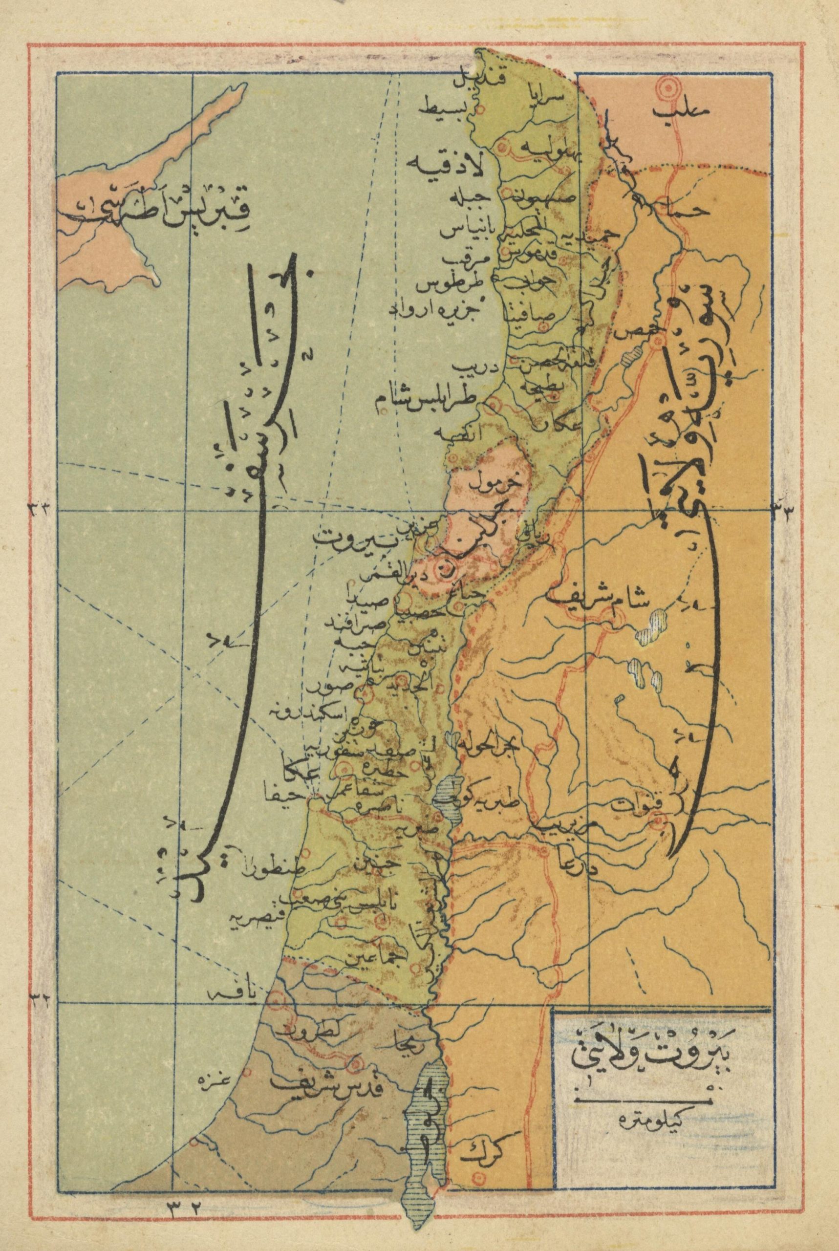
[Umum-i vilayat-ı Şahaneyi havi küçük atlas / Small Atlas] 5 RARE LOOSE POSTCARD-SIZE MAPS.
Esref, Mehmet
Synopsis
RARE LOOSE POSTCARD-SIZE MAPS, showcasing various countries of the world. They were issued unbound in a small Ottoman Atlas. This rare atlas included a 32-page brochure in Ottoman script and 128 maps (some composed of two parts), printed on thick paper and loosely inserted after the text. Many of the maps of certain areas worldwide are the first and possibly the only Ottoman maps of those regions. The atlas appears to be very rare and Worldcat only lists one example (Boğaziçi University Library, Istanbul).
Our maps come from an incomplete example comprising:
– Hejaz Railway, Palestine, Saudi Arabia with Mecca and Medina. (21023)
– Israel, Palestine. (21083)
– Lebanon. Right margin cut to the image. (21085)
– Lebanon, Palestine and Syria. (21081)
– Syria & Lebanon. (21080)


